Current Location
(enter callsign KG6NNZ)
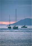
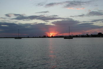
Logbook: Western Caribbean, March to May 2007
After transiting the Panama Canal, we were excited to snorkel and dive in the Caribbean's beautiful clear waters. Although the snorkeling and diving is good in the Eastern Pacific, the reefs are not as beautiful and the water is not as clear as the Caribbean. However, the Eastern Pacific must be richer in fish food, because a lot of the reef fish are significantly bigger there.
|
Click here
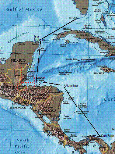
for photos. Because we passed through Western Caribbean rather quickly (wanting to get to Florida and then work our way up the U.S. East Coast before hurricane season set in), we never really assimilated into the Caribbean cruising community, but we met some nice folks along the way. With the steady trade winds blowing in the Caribbean, we had good sailing winds more often than in the Pacific. However, the seas were also rougher than we were used to in the Pacific, and we were surprised that we had queasy stomachs on some of the passages. We hadn't needed any seasickness medications in the past couple of years, but after a couple of rough passages, we started taking them pretty regularly. Fortunately, neither of us gets severely seasick, and after a half dose of Stugeron (Latin America's answer to Dramamine), we felt fine. (Jan took a whole dose of Stugeron one time, and she promptly went to sleep for several hours! After that, we cut the pills in half.) Although we had two months to get to Florida, we had some distance to cover (almost 1400 nm), so we needed to watch for good weather windows to head north and take advantage of them when they opened. Before heading north, though, we wanted to go east to check out Panama's San Blas Islands, which we'd been reading about since we decided to go cruising. From the San Blas, we headed to Columbia's Isla Providencia and then through the Northwest Caribbean, stopping in Honduras (Cayos Vivorillos, the Bay Islands and La Ceiba on the mainland) and Isla Mujeres, Mexico. We enjoyed this area so much and felt like we missed a lot (reportedly great diving in Belize) that we decided to go back and spend more time there this coming winter. |
 |
Colon, Panama (3/5-7). After our Canal transit, we anchored in The Flats anchorage near the town of Colon. Colon has a very bad reputation - thefts and assaults occur on a regular basis - so we planned to get out of here as soon as possible. Our friend Chris from Virginia was still on board Slip Away, and we also wanted to show him more of Panama before he returned to the States. We spent a day putting Slip Away back together - dinghy on the davits, outboard on the stern rail, solar panels in place, and so forth - and did a trip to the grocery store (via taxi), and then we moved on.
Portobelo, Panama (3/7-8). Our passage from Colon to Portobelo (26.6 nm, 6 hours) was not a smooth introduction to Caribbean sailing. When we cleared the breakwall at Colon, we were bashing into 5-6 foot closely spaced seas. The wind wasn't too strong (about 15 knots), but it was only 30 degrees off our bow, which is too close for Slip Away to sail, so we had to motor. However, as we got away from Colon, the seas settled down, the wind backed to 60 degrees off our bow, and we were able to turn off the motor and enjoy a nice sail for a couple of hours.
Portobelo looked like an interesting stop enroute to the San Blas Islands. It was the principal Spanish port in Central America for about 200 years. Portobelo was attacked by both the British and pirates, and there are a number of old forts to explore. Our friends Jay & Danica from Alkahest transited the Canal a few days before us, and they were anchored in Portobelo, so we were looking forward to catching up with them. It was also a convenient port from where our friend Chris could catch a bus back to Panama City for his flight back to the States.
Unfortunately, our time in Portobelo was cut short because our first night there, a crazy Frenchman set fire to another sailboat in the harbor. We were anchored on the opposite side of the bay and not personally affected by the attack, but rather than wait for the Panama authorities to take action (this guy had been causing trouble for some time, and no action had been taken so far), and not knowing what the crazy Frenchman might do next, we decided to move on. We did go into town and take a quick walk around before departing, but we didn't really get the opportunity to do much exploring here.
| Isla Linton, Panama (3/8-17). Isla Linton was just a short distance (11
nm) from Portobello, and Chris could still catch a bus back to Panama City from
there. We didn't really intend to spend nine days at Isla Linton, but somehow that happened.
We had a few rainy days here, but we enjoyed the downtime because we'd been running at full speed since before our canal transit. (We're supposed to be retired!) After a couple of days in Linton, Chris took a bus to Panama City to catch his flight home. That afternoon, a familiar boat pulled into Linton and anchored next to us - it was John & Barbara on Songline, friends we'd met a couple of years ago in Ensenada, Mexico. We'd kept in touch and knew they had transited the Canal a couple months before us, and earlier in the day, Jan said to Rich, "I wonder where Songline is - we should send them an email." Mental telepathy! We enjoyed a nice reunion dinner with them on Slip Away. |
|
Shortly after arriving in Linton, Rich broke a tooth, and he needed to see a dentist. We had the telephone number for a good dentist in Panama City, and he was able to get an appointment a couple of days later. The trip to the dentist would require an overnight stay in Panama City, so we got in touch with Pat & Carrie on Terra Firma to ask if Rich could use their guest berth for a night. The morning Rich was getting ready to leave, we asked some folks on the radio for information on the local buses, and Tom on Kiwi (someone we hadn't yet met) called and said he and his wife Julie were driving to Panama City that day, and they'd be happy to give Rich a lift. Cruisers are such a nice group of folks!
The dentist told Rich he needed a crown, but that would require that he stay in Panama City about 5 days - not good timing! Since Rich wasn't in any pain, the dentist agreed to do a temporary fix, with the understanding that we would need to stop somewhere and get a crown done in the next few months.
After Rich returned from Panama City, we spent a couple more days in Linton. We got together for lunch with Tom & Julie on Kiwi - very nice folks and new friends. They had spent a couple years in Panama on the Caribbean side and shared with us all their favorite spots.
Chichime, San Blas Islands (3/17-21). The passage from Linton to Chichime was 45 nm (9 hours), so we left early in the morning. We sailed about half of the trip, and caught a small tuna, but he escaped just before we got him on board. Bummer! We traveled in the company of Claude and Claire on Wapiti (a French couple we met in Linton), and they caught a nice sized wahoo (too much for their freezer), so they shared some of it with us, which helped us forget about the tuna we lost.
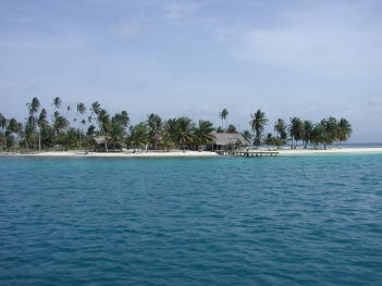
| Chichime was our first stop
in Panama's San Blas Islands. The San
Blas is an archipelago with nearly 400 islands off Panama's northeast
coast. Much of it looks like a postcard - lots of small islets with palm
trees and white sand beaches dotting a turquoise blue sea - absolutely beautiful! These
islands and the strip of Caribbean coastline adjacent to them are known as Kuna
Yala. The area is home to the Kuna Indians, and although part of Panama,
they operate autonomously with their own government, language and customs.
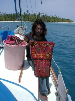
The Kunas are very protective of their land and culture and recently started
enforcing some new rules, including a ban on scuba diving, which was a big
disappointment to us. The economy of Kuna Yala is based on coconut trading and fishing. The Kuna
also make and sell "molas" which are traditional handicrafts made of brightly
colored fabrics sewn together and depicting landscapes, animals and other
maze-like patterns. Molas are generally made by women, but a couple of the
more famous mola makers are transvestites. We bought several molas.
The Kunas are very friendly, and several of them came by Slip Away in their canoes (called "ulus") to say hello, invite us to visit their island and offer molas and other crafts for sale. One young man, Raul, spoke English pretty well and organized a tour for some of the cruisers anchored in Chichime. He took us to the Carti Islands (about ten miles from Chichime), which have the most dense population in Kuna Yala. We walked around a couple of the islands, visited their museum, had lunch with Raul's family, and he also took us up a river to see their graveyard (which we were asked not to photograph). It was a great day, and a nice introduction to the local culture. |
|
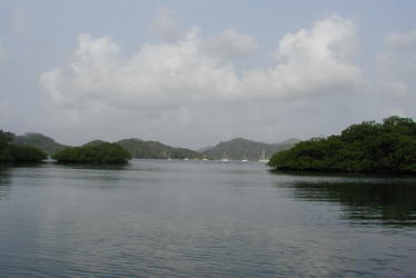
After a few days in Chichime, our friends on Alkahest and Wapiti decided to take advantage of a weather window to head north to Isla Providencia, a Columbian island off the coast of Nicaragua. We thought about joining them for the passage, but when it looked like the weather would hold for a few more days, we decided to eke out some more time in the San Blas. Although we enjoyed Chichime, it was a bit too busy for us. Chichime is often the last stop in the San Blas for folks heading to the Panamanian mainland or the first stop for those coming in the opposite direction, so it can get a little crowded (there were 20-25 boats when we were there). We wanted to spend a couple of days in one of San Blas' more peaceful anchorages, so we headed to the West Lemmons.
| West Lemmon Cays, San Blas
Islands (3/21-24). The West Lemmon Cays
were only 3½ miles from Chichime, but it was a much
different place. Here, there were only three or four other boats, and the
anchorage was protected and more comfortable. Getting into the
anchorage was a little scary as there were some shallow spots, and our depth
sounder had pooped out on us. Fortunately, the water was very
clear, and as we entered, Rich stood on the bow and gave directions to Jan
who steered us in. We have walkie-talkie headsets, so we can
communicate without hollering at one another, which helps keep us happily
married. We found an absolutely wonderful snorkeling reef here - the water was sparkling clear and the reef was alive and colorful with lots of corals, sponges, sea fans, anenomes and tube worms (feather dusters and Christmas tree worms). We even saw one of our favorite fishes, a spotted drum. We would have liked to dive on this reef, but we respected the Kuna's "no scuba diving" rule. |
|
Isla Providencia (3/26-4/4). The passage from the West Lemmon Cays to Isla Providencia was 280 nm and took us 59 hours. We sailed a little over 1/3 of the way (21½ hours), but motored the last 20 hours so that we could get in more quickly because we needed to sort out a problem with our generator. We arrived at Isla Providencia's harbor entrance in the early evening, about an hour after sunset. Normally we don't enter an unknown harbor after dark, but it was marked with flashing lights, and with coaching over the radio from Danica & Jay on Alkahest, who were already anchored there, we made it in just fine. Fortunately, after getting into Isla Providencia and doing some troubleshooting on the generator, we found the problem to be a broken wire, which was easily repaired.
The island of Providencia (Heaven) is situated off the coast of Nicaragua, but it is owned by Columbia, a vestige of the days when Panama was part of Columbia. It is a mountainous island covering an area of 10 square miles (4 miles north-to-south and 2.5 miles east-to-west), and its population is about 4,800. There's an airport on the island, but there's very little tourism here. The island is laid-back, and the people are friendly. Most of the islanders speak English; however, they have an unusual accent, and we often had a hard time understanding them. Cruisers are required to use an agent (Mr. Bush) to check-in with officials here, and he was happy to help provide whatever other assistance we needed. However, the laundry service was the most expensive we ever found, and it was returned with a couple of grasshoppers in it! There were a couple of internet cafes in town, but the connection speed was slower than dial up, so after a couple of tries at downloading our "slipaway.net" email, we gave up.
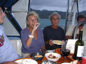
We spent eight days here, and it was a nice stop. One day, we took a short hike to Catalina Island, across Lovers Bridge from the main island, to visit Fort Warwick and check out the vistas of the harbor. On our way back to the boat that day, we stopped at the Bamboo Seafood restaurant and met the proprietor, Barbara, who introduced us to the local moonshine called "bushy" and showed us their still in the backyard. Another day, we found some nice snorkeling on a reef just outside the harbor. One Sunday, we rented motor scooters with Danica & Jay from Alkahest and Wayne & Bibi from Discovery and rode them around the island. (There is only one road that goes around the island, so we couldn't get lost.) It was Palm Sunday, and we timed it right to watch a procession from town to the Catholic Church.
| While here, we also enjoyed a few get-togethers with the
other cruisers in the
anchorage. It was during one such gathering that we learned a new meaning
for the name "Slip Away." We were on Wapiti, which is owned by Claire &
Claude who are French. Both speak English very well, but every once in a
while Claire would ask us to explain something she didn't understand. That
evening, Claire asked us "What is the meaning of 'Slip Away'?" and we explained
that it was to leave quietly or without others noticing. She laughed and
told us she had been wondering what it meant because in French, "slip" is
underwear, and when she saw "Slip Away" she thought it meant ... and she stood up
and acted like she was pulling her pants down. We're still laughing about
that!
From Isla Providencia, we said good-bye to our friends Jay & Danica on Alkahest, who left from there for a passage to Key West. From Key West, Alkahest was headed to Norfolk, Virginia, to go back to work for a while, so we were looking forward to seeing them again when we got up to the Chesapeake. (We were going to miss Friday pizza nights on Alkahest until we caught up with them again!) Wapiti stayed on to spend some additional time in Isla Providencia, and we took off for the Vivorillos Cays, in southern Honduras. |
|
Cayos Vivorillos (4/6-4/10). The passage from Isla Providencia was 189 nm and took us 47 hours. Shortly after leaving the harbor at Isla Providencia, we turned off the engine, and we sailed for the next 29 hours. We started out making good time with brisk winds and a push from the current. When the winds lightened up, we continued to sail slowly, but when the wind died completely and we quit making headway, we gave up and started the engine.
| One of the challenges of cruising in this area is that there's not really a
good recent cruising guide written for it. There are a couple of old
guides from the 1980's that are out of print and hard to come by. We have
John Rains' Cruising Ports: Florida to California via Panama, which covers
most of the major harbors along
the way, but Rains often skips over remote anchorages, which are usually
our favorites. We have charts (both paper and electronic), but they're not
always completely accurate, which can be very scary in an area with lots of
shallow reefs. Fortunately, some cruisers put together a CD with waypoints
and aerial photographs of many of the anchorages. Wayne & Bibi on
Discovery shared that with us, and we in turn shared it with others we met
along the way. The waypoints and other information on this CD
gave us more confidence to navigate the area safely, especially with our
intermittently working (mostly non-working) depth-sounder.
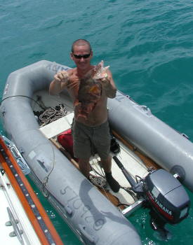
The Vivorillos, owned by Honduras, are a very remote group of small islets. We spent a few days here snorkeling, relaxing and meeting some new friends. The cruisers we met here introduced us to some of the excellent seafoods that can be harvested in the Caribbean. Kaija & Gary (Kaija's Song) came over one evening for cocktails and brought conch fritters with them. Yum! Also, it was here that got our first taste of hogfish, which is now one of our favorite fishes. Gene & Brenda on Queen Mary shared some with us one night at dinner, and then Mike on Sculpin speared one and gave it to us. When we pan fried it in olive oil with some seasonings, it melted in our mouths. We need to work on shooting some of those! |
|
Also, Rich earned a new nickname here from Gene on Queen Mary. When Gene and Brenda dinghied over to Slip Away to say hello, Rich introduced himself and told Gene that his name is a bit of an oxy-moron because he's not wealthy. Gene decided to call Rich "moron" for short, and we took an immediate liking to him.
After a few days in the Vivorillos, we felt like we needed to move on. We still had a month before we wanted to get to Key West, but time was passing quickly.
Josh's Cay, Guanaja, Bay Islands, Honduras (4/11-14). Our passage from the Vivorillos to Josh's Cay (149 nm, 27½ hours) was a rollicking sail and the roughest conditions we've ever sailed in. We left the Vivorillos early in the morning with what sounded like an excellent weather forecast - 10-15 knots of wind out of the southeast. Since our course was primarily northwest, this would be perfect. We weighed anchor, motored for an hour to charge the batteries, and then started sailing wing-and-wing in 12-15 knots of wind. By about noon, the winds had built to 15-20 knots, but it was still a very pleasant sail. By about 2 p.m., it was blowing 20-25 knots, and we put a second reef in the main. The seas were getting a little rough, so we decided to bring in our fishing lines. We were trolling a line off our fishing pole, as well as a hand-line, and when we went back to haul in the lines, we saw that we had hooked a fish on our hand-line - a 44" wahoo. Excellent! Cleaning the fish on the front deck with the rough seas was a bit of a challenge for Rich, but he managed to keep both himself and the fish on board. The wind continued to build during the afternoon, and by early evening, we rolled up the headsail and continued on with just a double-reefed main. It blew in the upper 20's and low 30's until just after midnight. At one point, Rich saw Slip Away's speed over ground hit 10 knots as we surfed down the front of a wave. When Jan came into the cockpit to take over the watch at midnight, she looked at the wind instruments and saw 34 knots. Fortunately, the wind peaked about that time, and by 1 a.m., we were back down to 15-20 knots. Slip Away handled the wind and seas just fine, but we didn't get much sleep on that passage, and we pulled into Guanaja ready for a nice long nap!
At Guanaja, we took a free mooring ball at Graham's Place on Josh's Cay. Graham is a guy from the Cayman Islands who bought this islet and built a small resort, with a guesthouse, bar and restaurant and a great little aquarium. He doesn't mind if you use his mooring balls, as long as you reciprocate by spending some money at his bar. We spent our first day here resting up from that spirited overnight passage, but we went ashore the next day to check out the place and have lunch. It was a nice, laid-back and quaint resort, and the people were very friendly. We intended to go back ashore the next day and take some photos, but it was another windy day (blowing 25-30 knots), so we stayed on Slip Away.
Port Royal, Roatan, Bay Islands, Honduras (4/14-4/17). The comment written in our ship's log about our sail from Josh's Cay on Guanaja to Port Royal on Roatan was "delightful!" (30 nm, 5½ hours). We had 15-20 knots of wind from our stern and calm seas, and we sailed wing-and-wing for most of the way. What a difference from that last passage!
The Port Royal anchorage was pretty quiet, with only a couple other boats in it. There were some private residences and guesthouses ashore, but there weren't many people around. Funny thing, though - we picked up a wireless internet signal here, and it was high-speed, so Jan was able to upload a couple of web pages.
We snorkeled here, and the reef was absolutely beautiful. If we'd had more time, we would have hauled out our scuba gear, but we needed to move on. We'd gotten a recommendation for a dentist in La Ceiba, Honduras (on the mainland), so we'd set an appointment for Rich to get his broken tooth crowned.
La Ceiba, Honduras (4/17-4/28, 45.9 nm, 8½ hours). As we were preparing to depart Port Royal for La Ceiba, we turned on our sailing instruments, and saw that now not only was our depth sounder not working, but also the instrument that provides our boat speed, sea temperature and trip log was not working. We could still get our speed over ground (from the GPS), but without boat speed, we couldn't tell how much current was helping or hurting us. Bummer! These instruments were installed just four years ago before we left California. We needed to get in touch with and do some complaining to Simrad (the manufacturer).
Our trip to La Ceiba was a motor boat ride - no wind and the sea had only a slight swell. We caught a fish while underway, but it wasn't an edible one, so it went back to the sea. Unfortunately, during this passage, we lost Jan's favorite fishing lure (the one on which she caught several yellowtail in the Sea of Cortez). We were trailing it on a hand line, and as we arrived in La Ceiba and pulled in our lines, it was gone - guess a big fish got that one!
We could not access La Ceiba from an anchorage, so we would need to stay at Lagoon Marina while Rich had his dental work done. Although we'd tied up to some mooring balls and even a floating "docklet" in Costa Rica, we hadn't been in a full-fledged marina with shore power for almost a year. Our shore power cord was buried, but we managed to find it, and after tying up, we plugged it in - and, it still worked!
Shortly after we arrived, we learned that Lagoon Marina was a dealer for Simrad Instruments, and they could get us replacement parts for our malfunctioning electronics if we could determine what we needed. (Unfortunately, they were only dealers and not technicians.) After some discussion, we concluded that the most likely cause of our problems was a bad transceiver. They ordered us a replacement, and after paying to have it air-shipped to Honduras, we installed it, and unfortunately, that didn't change anything. We then ended up buying a fish-finder to use as a temporary depth-sounder until we could get our electronics fixed.
| Another reason for coming to La Ceiba was to catch up with Neil & Kathy Farley on a boat named Attitude. Neil was Jan's boss at Procter & Gamble in the 1980's, and they hadn't seen each other since then - 20 years ago! Mutual friends got them in touch via email, and our paths finally crossed. Attitude was hauled out for some maintenance work in the La Ceiba shipyard, which is right next door to Lagoon Marina. We got together with Neil & Kathy a number of times during our stay in La Ceiba, and we had so much fun, we wished we weren't heading in opposite directions. Neil said Jan looked the same - a very nice compliment since she's 20 years older! Jan couldn't say the same for Neil. It's not that he looked older - just different. When they worked together at P&G, Neil was clean shaven, wore a conservative haircut and pinstriped suits. He has since shaved his head, grown a goatee, wears an earring and has a couple of tattoos - and it all seems to suit him well. The four of us will be in Cincinnati in September, so we plan to get together again at that time. And, it wouldn't surprise us at all if some day Attitude and Slip Away ended up in the same anchorage somewhere in the world. |
|
La Ceiba is a nice-sized town (population 113,000), so it was a good place for us to take care of some personal business before our return to the U.S. Rich got his tooth crowned for a fraction of what it would have cost in the states ($150 in La Ceiba), and the quality of work is just fine. We both saw the dentist to get our teeth cleaned ($30 each). Also, Rich needed to restock his supply of blood pressure and cholesterol medications, and we could buy them over the counter and cheaper here than in the U.S.
An added bonus to all this is that we really enjoyed our stay at Lagoon Marina. This small marina is set back in the mangroves, which has its plusses and minuses. It was calm and protected, and the birdsongs were delightful, but it was often hot and buggy. When the heat or bugs or both were too much, we either turned on our air conditioner or cooled off in the marina's nice swimming pool. The owners of the marina - Tony & Rita - are German, and they not only keep their facilities in top shape but they also provide some nice touches, like flowers in the bathrooms and beautifully planted grounds. They are former cruisers, and they have a well stocked chandlery and offer just about all the services that cruisers need and want (from mechanical assistance to daily shuttle runs into town, help filling propane tanks, deliveries of cases of soft drinks and beer and more). And, the staff is very friendly. We generally prefer not to go into marinas, but we would stop in again here.
Utila, Bay Islands, Honduras (4/28-5/3). Our passage from La Ceiba to Utila in the Bay Islands (21 nm, 4½ hours) was another spirited sail - a close reach with with 20-25 knots of wind. It was a short trip, so we got there quickly.
| We were looking forward to
doing some diving on Utila. This island is visited by whale sharks in
the winter and spring, so we were hoping to catch a glimpse of them. It
seemed like our best chance to see the whale sharks was to go out diving with a local dive shop. We hadn't had
the opportunity to do much diving since arriving in
the Caribbean, so we decided to splurge and book a full day - 2 dives in
the morning and 2 in the afternoon. Unfortunately, the whale sharks
eluded us, but we still had a great day. The water was
clear and the reefs were beautiful.
Although we'd heard some mixed reviews on Utila, we really enjoyed this island. Other cruisers told us there can be a problem with theft from boats after dark, so we always stayed aboard Slip Away in the evening, but we spent a couple afternoons wandering around the town on the island and found a couple of good restaurants and ice cream spots. |
|
While here, we watched for a weather window to head north to Key West. We'd hoped to go straight from Utila to Key West, but the next weather window that opened wasn't long enough for us to make it all the way there. So, we decided to break up the trip with a stop in Isla Mujeres, Mexico (off the coast of Cancun).
Passage from Utila to Isla Mujeres, Mexico (5/3-5, 325 nm, 51 hours). We had good wind and a nice current pushing us for most of this passage, and we averaged 6.5 knots speed over ground, our fastest passage ever. (Since our boat speed instrument wasn't working, we don't know what was our average "boat speed" vs "speed over ground", which would have told us how much of our speed was attributable to current.) We left Utila's harbor at 8 a.m. and for the first three hours, the wind was light and variable, so we motored. But, around 11 a.m., the wind started blowing, and we sailed on a beam reach for the next 46 hours. For a while the wind blew in the low 20's, which made the seas a bit rough, but on the second day of our passage, we had ideal conditions (about 15 knots of wind and 3-4 foot seas). When we reached the Yucatan Channel, even without our boat speed instruments, we knew the current was moving quickly. We had a couple of hours with light winds, but our speed over ground was over 8 knots! As we arrived Isla Mujeres, we saw the prettiest water we'd ever seen. The channel between Isla Mujeres and Cancun isn't very deep, the bottom is white sand, and the water is a beautiful, clear aquamarine blue. It was incredibly gorgeous! As we sailed past Cancun, we saw lots of huge hotels lining the beach, and Jan reminisced about how that beach was empty when she worked at the Cancun Club Med in 1986.
Isla Mujeres, Mexico (5/5-9). We hung out in Isla Mujeres (the Island of Women) for a few days waiting for good weather to make our passage to Key West. It was nice to be back in Mexico - it felt a little like coming home, and we had really missed Mexican food. We did some shopping and worked on a few boat chores. Jan made contact with an old Club Med friend who still lives in Cancun, but because our stay was so short here, they weren't able to get together. We expect to return to this area next winter, so they hope to see each other then. We met a few other cruisers who were also looking to make the passage to Key West, and when the weather looked right, we gathered on Slip Away for cocktails and a passage-planning meeting. One of the things we learned during this get together was that there is a web page that shows the Gulf Stream by infra-red imagery. This helped us plan our passage to take advantage of the Gulf Stream current. (Here's the link - http://polar.ncep.noaa.gov/ofs/aofs_images/aofs_cur_nowcast_hurr.png - it's pretty neat!)
| Passage from Isla Mujeres to Key
West, FL (5/9-5/12, 386 nm, 65 hours). Our weather window looked good for a calm trip
to Key West,
but not much sailing. However, since prevailing winds would normally be on
our nose for this passage, we were happy to have a forecast for light winds, so
we could motor without bashing into rough seas. We were able to sail for a
bit at the start of the trip, but then we had to turn on the engine for the
remaining 50 hours. In an attempt to take advantage of the Gulf Stream
current, we didn't sail a straight line. In the end, we traveled more
miles and didn't save any time, but it was a good learning experience, and
it was fun getting a faster ride in the current.
It was a little unnerving doing this passage as the Atlantic's first named storm of the season (Andrea) developed off the Carolina Coast, but fortunately, that was far away and did not affect us. The time passed by uneventfully, and we kept in contact via the radio on a regular basis with the other boats who were doing the passage with us. We caught a dorado our second day out, so we were happy that we would arrive Key West with some fish in the freezer. Our second night out, we saw a couple of Coast Guard Cutters standing guard along the north coast of Cuba, but they did not board and inspect us, as they did our friends on Alkahest who passed through this area a few weeks before. We arrived Key West shortly after daybreak on Saturday, 5/12. The air was hazy and smoky due to fires that were burning further north in the state, which had been suffering from a severe drought. |
|
We motored into Key West Harbor, looked for a spot to anchor and came close to running aground in the shallow anchorage area. Now, that would have been an auspicious arrival! Fortunately, we avoided that calamity (thanks to our new fish finder), and we found a spot to drop our anchor, and gave each other a good, long hug. Over 7,500 miles had passed beneath our keel since leaving Los Angeles in 2003, and we had successfully sailed Slip Away from the West Coast to the East Coast of the U.S. - we were pretty proud of ourselves!