Current Location
(enter callsign KG6NNZ)
Logbook: January and February, 2007 - Pacific Panama
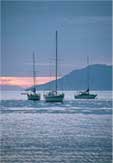
The Pacific side of Panama has a well deserved reputation for outstanding cruising grounds. The Western Islands (Parida, Secas, Contreras and Coiba) are remote and beautiful. During the time we cruised that area, there were probably less than ten cruising boats in the entire area. The Perlas Islands in the Bay of Panama are closer to Panama City and draw more visitors than the Western Islands, but they are still quite undeveloped and very beautiful. Panama City is described as the "cross-roads of the world", and we thoroughly enjoyed the international community. Supplies and services are abundant in Panama City, which was a nice change for those of us who had been cruising in remote areas for a while. And, the locals here are among the friendliest we've found. We spent five weeks cruising the Pacific coast of Panama, and just over three weeks in Panama City, and it was not nearly enough time to take it all in.
The Republic of Panama
Archaeological evidence shows that people have been living in Panama for at least 11,000 years. Panama's first inhabitants lived beside the Pacific and fished in mangroves and estuaries, just as many of the country's native people do today. When the Spaniards first arrived on the isthmus of Panama in the early 16th century, they found it inhabited by several dozen native tribes, but the indigenous peoples were decimated by European diseases and Spanish conquistadors. Only seven of the original tribes exist today.
In 1739 Panama became a province of Columbia, and in 1821 Columbia gained independence from Spain. In 1903, Panama declared independence from Columbia with support from the U.S. so that the U.S. could build the Panama Canal. The U.S. military was active in Panama's political affairs until 1936, when the U.S. relinquished its rights to use its troops outside the Canal Zone. In 1977, U.S. President Jimmy Carter and Panamanian President Omar Torrijos signed a treaty which would phase out U.S. control of the Canal and turn over ownership to Panama on December 31, 1999.
President Torrijos was killed in a plane crash in 1981, and in 1983, Manuel Noriega (a former head of Panama's secret police and a former operative of the U.S. CIA) took control of the country. In 1988, the U.S. indicted Noriega for drug trafficking and involvement in organized crime, and then imposed economic sanctions against Panama. In 1989, Noriega announced that Panama was at war with the U.S., and the next day, an unarmed U.S. marine dressed in civilian clothes was killed by Panamanian soldiers. The U.S. reacted immediately and attacked Panama City. Within days, Noriega went to the Vatican embassy for asylum and stayed there for 10 days before surrendering to U.S. forces. He was flown to Miami, convicted on eight charges of conspiracy to manufacture and distribute cocaine, and sentenced to 40 years in prison.
Since Noriega's ousting, Panama's presidents have been elected by democratic elections, and they have worked toward putting their country back together again. The current President of Panama is Martin Torrijos, who is the son of the late President Omar Torrijos. Given the amount of new construction we saw in Panama City, it appears their economy is presently doing well.
Panama covers an area of 30,193 square miles, which is slightly smaller than the state of South Carolina. The isthmus of Panama is the narrowest land mass between the Atlantic and Pacific oceans. Two mountain chains run along Panama's spine, and dormant Volcán Barú, the country's only volcano, is the highest point in the country at 11,400 feet (3475 meters). There are about 480 rivers in Panama and over 1500 islands. Panama has set aside about 30% of its land for habitat protection, but they face deforestation problems due to poor enforcement of its laws.
Panama's population is just over 3 million, and the majority (65%) are of mixed indigenous and Spanish descent. Other groups include 14% of African descent, 10% of Spanish descent, 5% mixed African and Spanish, and 5% indigenous. 85% of Panamanians are Roman Catholic. Panama has the highest per capita income in Central America, but 37% of the population live below the poverty level. Panama uses the U.S. dollar as its currency; however, the official name for it is the "balboa". The paper money is exactly the same, but they mint their own coins, which are the same value, size and metal as U.S. coins, but with a different design, and businesses will accept either. Spanish is the official language, but English is widely spoken in Panama City. We found more English spoken here than anywhere in Latin America. Baseball is the national pastime, but they're also big soccer and boxing fans.
Cruising Panama
|
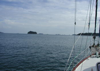
Isla Parida and neighboring islands (1/4-8, 89.5 nautical miles, 23 hours) We left Golfito, Costa Rica, in the afternoon and had light winds on our passage to Isla Parida, but it was enough to sail a good part of the way. Isla Parida is the first island we came to as we entered Western Panama. There were a number of anchorages on the Island of Parida, and lots of small islets near by. The setting was beautiful, but a little intimidating as we saw a number of rocks jutting out of the sea. Keeping a good watch in this area was absolutely necessary! We first anchored in Playa del Socorro on the northeast side of Isla Parida. Our first day here, some fisherman came by selling lobsters, and we bought four of them for $10, so we had a couple of delicious meals. We explored some of Parida's other coves in our dinghy and spent time in the water snorkeling. The sea temperature was a delightful 87°F, but visibility wasn't great and we didn't see many fish. One afternoon, we moved Slip Away to Isla Bolaños (about five miles from Parida), where we found better snorkeling. The anchorage at Isla Bolaños wasn't calm enough to spend the night, so we came back toward Parida and dropped our hook on the south side of Isla Gamez. |
|
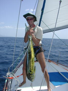
Passage to Islas Secas (1/8, 22 nm, 4 1/4 hours). From Isla Parida, we headed to another small group of islands called Islas Secas (the "Dry Islands"). Since it was a short trip, we waited until noon to leave in hopes that the wind would come up and we could sail the distance. It didn't, so we started out under motor. About an hour into this passage, Jan was looking out at the sea ahead of us (maybe a mile away) and she noticed what looked to be a very distinct wind line with lots of white caps behind it. Not knowing how much wind was headed our way, we double-reefed the main and motored toward it (we still only had a light breeze where we were). As we crossed the wind line, the wind quickly built to 15, then 20 knots, and we set our headsail, turned off the engine and started sailing. The wind was very shifty, and we changed course quite often to keep the boat on a close reach and heading as close to our destination as possible. Then, 40 minutes later, as quickly as we entered this windy spot, we left it. The wind died to almost nothing, and we turned the engine back on, rolled up the headsail and continued under motor. We could look behind us and see the wind still blowing strong in that area, but we were down to about five knots at our location. A couple of our friends sailed this route in the following days and ran into the same wind conditions. Very strange! Also, on this trip we were trolling our fishing line with a new lure that our friend Steve on Last Resort made for us. We hooked a good-sized dorado, and he did a couple of jumps out of the water, but then got away. The line snapped, and he took our new lure. Bummer!!
Islas Secas (1/8-1/15). Islas Secas are a small group of islands that are owned by a young hedge-fund company owner from Santa Barbara, California. He built an airstrip and very exclusive resort on one of the islands, Isla Cavada. The resort has a few "yurts" constructed on the island, and it is managed by a couple of ex-cruisers. We understand the guests of this resort pay mega-bucks ($1000/couple/night) to stay here, and we were asked (nicely) by the resort managers that if we saw their guests on the beach, we not speak to them. We didn't see anyone, although we did see and hear a couple of small planes land here.
We arrived Islas Secas in the afternoon, and we anchored on the east side of Isla Cavada, where the anchorage was calm and flat. As the sun set that evening, the winds came up and blew about 20 knots from the north, but the anchorage was protected from seas from that direction. The wind stopped blowing in the middle of the night, and then about 3 a.m., a big swell started rolling in from the east. The anchorage was wide open to seas from that direction, and it was pretty rolly and uncomfortable. This pattern repeated itself for three days in a row - calm, flat days with windy and rolly nights. We liked this area - it was beautiful and secluded, and had great snorkeling, but we weren't sleeping very well. Our cruising guides didn't indicate any other good anchorages, but it seemed like there should be some others, so we decided to go out in the dinghy and see if we could find one on our own. Pat & Carrie on Terra Firma had joined us by this point, and we had a fun day tooling around the islands in our dinghies in search of the perfect anchorage. At one point, some dolphins started swimming along with our dinghies. They were close enough to touch. In one of the bays where it was too shallow to bring the motherships, we saw a number of turtles.
| We finally found an anchoring spot on the southwest side of Isla Cavada - protected from the north wind and the east swell. Holding wasn't great (it was sand over rock), but it was calm, so we just put out extra chain in case the wind came up (and it didn't). We spent four more days at Isla Cavada in this anchorage and named it "Bahia Terra-way" in honor of its founders. We emailed the waypoint coordinates to friends who were following in our tracks, and some of them also spent time in this bay. We swam and snorkeled, hiked and had floating happy hours (rum drinks in the water on our rafts and swim noodles). We speared some trigger fish and had excellent meals. We found a huge colony of hermit crabs on a white sandy beach. We had a trash burning party and came upon a big iguana cooling off in the shower of a small waterfall - can't believe we didn't have our camera with us! These were a few idyllic days of cruising. |
|
Isla Medidor (1/15-17, 31.8 nm, 7 hrs). Although we loved Isla Cavada, we knew there were many more places to see in Western Panama, so we weighed anchor and headed off to Isla Medidor. Winds were light, and we motored for the first three hours, but then we set the spinnaker and had a outstanding 3½ hour run. We caught a number of fish along the way - a bonito, a skipjack and a jack crevalle - but none of those were ones we wanted to eat, and they all went back to the sea. We also caught a boobie bird - so aptly named - those stupid birds dive after our lures. We untangled and unhooked him, and if he hasn't gotten any smarter, he's probably no longer with us. Fortunately, Pat & Carrie on Terra Firma had better fishing luck and just as they entered this bay, they caught a tuna, which they shared with us. Yum!
Isla Medidor is owned by a European businessman, Jean Pigozzi, and on the island's highest peak, he is building a scientific laboratory where scientists will study marine ecosystems. (For more info visit www.liquidjunglelab.com.) There was quite a construction project going on. We dinghied into shore and met a local woman who was tidying up a beach house annex, and we asked if it was OK to visit the island. She assured us it was and directed us to a nice hiking path. We hiked around the island and up to the top of the hill where the construction project was happening. Along the way, we met a couple more people, who appeared to be managing the construction, and they, too, were very friendly, and told us we could walk around the site while the workers took a lunch break, which would be happening shortly. Very cool! As we were waiting for the workers to finish up before their break, we just hung out and observed. Supplies were being brought from the bay to the top of the hill by a monorail. Then, another guy stopped to talk to us, but this guy wasn't so friendly. He asked if we were from the sailboats in the bay, and when we said yes, he told us the island was private property, and the owner didn't like people wandering around on it. Darn! So, we hiked down the hill and went home to our boats.
| We learned during our visit that the owner was not on the island at that time, but his arrival was imminent. He showed up in style - on a 100+ foot yacht that looked like a research vessel. We caught a glimpse of Mr. Pigozzi and his young female companion as they were ferried ashore. We didn't notice Mr. Pigozzi so much as his female companion, who was tall, dark and lanky (Pat on Terra Firma insists it was one of the Williams' tennis pros). She was wearing a mini-skirt and thigh-high leather boots (stylish but a little impractical), but she was friendly and waved to us as they motored by. When they got to shore, Mr. Pigozzi hopped on an ATV and the young woman got to ride up the monorail. |
|
Bahia Honda (1/17-19, 9 nm, 2 hours). As we left Isla Medidor for Bahia Honda, Terra Firma caught another tuna in the same spot they caught the last one, but Slip Away got skunked again. Thank goodness they were willing to share with us! Bahia Honda is on the mainland, and we stopped at this anchorage because there is a settlement here, and we were hoping we might be able to get some fresh provisions. We'd been away from civilization for a couple of weeks, and although we had stocked up pretty well, we were running out of fresh stuff - veggies, eggs, bread. We'd heard about a guy here - Domingo - who would trade with cruisers for fruits and veggies that he grows on his farm. When we arrived, Domingo came out and greeted us right away. Domingo and his son Kennedy brought us some fresh fruit - bananas, pineapple, papaya - but unfortunately, they told us veggies were not in season. They were happy to accept money or other items in trade - clothing, a gallon of gas, a comb, school supplies. We were able to buy an onion in the little village, but we never found any eggs. Domingo told us a dog ate all their eggs! When we went into the village, a young guy walked us around to a number of houses asking if anyone had eggs for sale, but we received the same response everywhere - "No hay" - which meant they didn't have any. Bahia Honda is a very protected and calm anchorage, so it was a good place for Rich to make a trip up the mast. Our wind indicator was occasionally malfunctioning, so he took it off and checked and cleaned the connectors, hoping it was a simple fix. But fixes on boats are rarely simple, and this one was true to form. The wind indicator would continue to randomly malfunction.
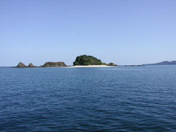
Isla Coiba (1/19-27, 20 nm, 5 1/2 hours). We left Bahia Honda enroute to Isla Coiba, which is the largest island in the Mesoamerican Pacific. Isla Coiba previously housed a penal colony, which was established in 1919, but has now been removed. Isla Coiba and its surrounding islands, are a National Park and are reputed to have some of Pacific Panama's best snorkeling and scuba diving. We started out from Bahia Honda intending to sail to Ensenada Santa Cruz on Isla Coiba, but the wind was coming from the direction we wanted to go. We tacked a couple of times, but decided we had a better angle for Isla Rancheria (still part of the Park) and went there instead.
When we arrived Isla Rancheria late in the afternoon, the anchorage was flat calm; however, just around sunset, a big swell started coming into the bay and we had a rolly night with very little sleep. Of course, the next morning it calmed down again. Although we didn't want to spend another night here, we decided we'd go for a snorkel before moving on. We were not disappointed. We had been forewarned that we would see white-tipped sharks in this area, and we saw a couple of those, as well as lots of varieties of fishes, a devil ray and a spotted eagle ray. As we swam back to Slip Away and climbed back on board, a turtle came by to check us out.
After our snorkel, we motored over to Ensenada Santa Cruz (yesterday's original destination), which provided much better protection for a peaceful night's sleep. We spent a couple nights there and snorkeled several spots. Currents were sometimes strong here, so Rich usually kept the dinghy tethered to him as we swam. We continued to see white-tipped sharks, as well as a number of eels, lots of other good fish life and two of the biggest spotted eagle rays we've ever seen swimming side by side.
| We spent the next several days moving
between anchorages and finding good snorkeling spots. We visited the
Ranger station, took them some chocolate chip cookies and paid our $10/person
registration fee. We went back to Isla Rancheria and anchored in a
different location (protected from the nightly swell), and we did a lot of our exploring from there,
including snorkeling and diving at Granita de Oro and Islas Cocos. There were lots of
squawking parrots flying around this anchorage, howler monkeys at night and the friendly turtle came by our boat at least once a
day, one time surfacing right next to our dinghy as we climbed into it.
We could have spent several more weeks at Isla Coiba. In addition to exploring under water, we would have liked to hike on shore and check out some of the rivers in our dinghy. However, because we were intending to transit the Panama Canal in early March, we needed to move on. |
|
Isla Cebaco (1/27-29, 39.6 nm, 8 hours). We left Isla Coiba headed for Ensenada Benao, which was about 100 miles away. Benao is a bay where boats wait for a weather window to round Punta Mala to enter the Bay of Panama , wherein lies the Perlas Islands and Panama City. When we left Isla Coiba, the weather forecast called for light and variable winds, so we planned to do an overnight passage to Benao, thinking we would probably need to motor some or all of the way. However, the winds we found were from the east - right on our nose - at about 15 knots, and driving into the seas was pretty unpleasant. We really didn't want to do this for 24 hours, especially when there were options for places to stop along the way. We talked on the VHF radio with Bill & Sandy on Hibiscus, a boat we spent time with at Coiba, and they told us they were in a nice anchorage at Isla Cebaco. We would still need to motor to get to Cebaco, but we could fall of the wind enough to get a lift from our sails and make it a more comfortable ride. When we arrived at Isla Cebaco, not only did we get to see Bill & Sandy again, but also they had stopped at Isla Catalina, which had some tiendas, and they picked up some fresh veggies, eggs and bread for us. Lucky us! We spent a couple of nights at Isla Cebaco and then continued on toward Benao.
| Ensenada Naranjo
(1/29, 23 nm, 5 3/4 hours). Rather than trying to make Ensenada Benao
in one passage from Cebaco, we decided to break up the trip and stop for a
night at Ensenada Naranjo, which friends recommended as a good stop.
We had an outstanding close reach sail from Isla Cebaco to Ensenada Naranjo
in 15 knots of wind. To top it off, we landed a 20 lb. dorado while
underway. We were happy campers! We spent one rolly night in
Naranjo and moved on.
Ensenada Benao (1/30-2/2, 54.5 nm, 10 hours). We left Naranjo before daylight because this would be a long-ish day trip, and we wanted to arrive Benao before dark. For the first six hours of this passage, we had a push from the current, and very fluky winds. The winds were coming from the north-northeast, and we were headed east, so the wind direction was OK, but at one point the winds were up to 27 knots, then 20 minutes later they were down to 5 knots. The coastline is mountainous here, and we were experiencing winds that funnel through passes. We kept the mainsail double-reefed and powered on. About 2/3 of the distance into the passage, we reached Morro de Puercos (the snout of the pig), and altered our course to northeast. The winds increased to 20-25 knots, and the current started running against us. It took us six hours to go half the distance that we covered in the first five hours, but we pulled into Ensenada Benao in the late afternoon and found a comfortable spot to anchor. Slip Away was covered in salt spray from the passages of the past few days, but we were getting closer to Punta Mala, which was now 14 miles away, and the last obstacle in our course to Panama City. |
|
We've had to round other challenging points and capes in our travels, but Punta Mala ("Bad Point") seemed to have the worst reputation. Big tides and strong currents run through the Bay of Panama, and they can churn up some pretty rough seas. Additionally, the Caribbean trade winds funnel over the low point of the Panamanian peninsula (where the Canal was built), so it can get pretty windy at the point, especially in the winter when the trades blow stronger. The key to a successful rounding is light winds; as long as the winds aren't too bad, the seas are usually manageable. The rule of thumb is to round at high tide, and don't go if the winds in Ensenada Benao are over 15 knots. In addition to the winds, currents and tides, this is an area with lots of freighter traffic - ships going to and from the Panama Canal.
We spent three days in Ensenada Benao waiting for our weather window to round Punta Mala. The first couple of days the winds blew 20-25 knots in the anchorage. We listened to weather forecasts, and it looked like Friday, February 2, the winds would calm down and we could get around the point. High tide would be at 4 a.m., and we would have a full moon, which is great for visibility on a night passage (but not so great because tides are bigger in the full moon). By rounding Punta Mala at such an early hour, we could possibly make our next anchorage (Isla San Jose in the Perlas Islands) before dark.
While we waited in Ensenada Benao, we hung out on Slip Away. Jan worked on the website, and Rich took a break from boat chores and spent a couple of days reading (one of his favorite pastimes). One evening, we decided to turn on the SSB radio to see if we could hear the "Southbound Net", which is an evening radio net in Mexico. We got lucky because propagation was good, and we could hear it well. We checked in and said hello to a number of our cruising friends in Mexico. That was a nice bonus!
On Thursday, the winds lightened up, and in the afternoon, it was calm in Benao. (There was also a high tide on Thursday afternoon, and we sat there wondering if we should have gone on that one.) We went to bed about 7 p.m. to try and get some sleep, and about 10:30 p.m., Jan woke up when she heard the winds start to blow again.
Rounding Punta Mala / Passage to Isla San Jose (2/2, 88 miles, 17 hours). We weighed anchor at 1 a.m. and started toward Punta Mala. The full moon was up, and it was blowing 15 knots in the anchorage when we left. We set a double-reefed mainsail and planned to motor-sail on this passage. (Sometimes it's just better to motor through the crappy stuff!)
About half way down the coast to the point, winds built to 20 knots, but then they died down to 10-15 as we got closer to the point. We saw three freighters on our radar, two of which were headed away from us, and one of which was approaching from the other side of Punta Mala. When that freighter reached the point, he turned directly toward us - Eek!! We changed course and moved closer to the coast, and he passed about ¼ mile away from us.
Just after passing the point, the winds built to 20 knots again, but that was the most wind we saw - no problem! The seas were confused and uncomfortable, which was the worst part, but they were definitely manageable. Our weatherman told us to expect about 30 miles of confused seas after rounding Punta Mala, but for us, they lasted about 40 miles. We think the bigger tides associated with the full moon probably contributed to that. We pushed Slip Away's engine a little harder than normal, but she ran like a champ. We hoisted the headsail and staysail and got an additional lift from them, which was good because the current was against us. We kept a close watch for freighters traveling to and from the Panama Canal, and the radar was an incredible help with that. The ships made a big "hit" on our radar screen - we could always see them with that before we could find them with our eyes. A couple of ships passed a bit closer than we would have liked, but there were no real close calls.
We made it to Isla San Jose in 17 hours and dropped our hook just after 6 p.m. and just before the sun set. We popped open a couple of beers and toasted our successful passage. We had previously arranged to contact our friends Pat & Carrie on Terra Firma on the SSB radio at 7 p.m., and they were clearly happy to hear that we had made it safe and sound. They had rounded Punta Mala about one week prior to us, and although they had no problems, another boat they traveled with had engine problems, which made for an unpleasant trip for both.
Isla Cañas (2/3, 26 miles, 5 hours). We spent one night at Isla San Jose, but moved on to Isla Cañas the next day because we wanted to catch up with some friends. Since we would be transiting the Canal soon, we wouldn't have much more time together.
|
Isla Espiritu Santo (2/4-6, 10 nm, 2 hours).
After one night at Isla Cañas, the next day we moved on to Isla Espiritu
Santo to meet up with Pat & Carrie on Terra Firma and Steve & Susan on Last
Resort. While in Isla
Cañas, we ran into Brian & Marilyn on Icarian, a
couple we hadn't seen since Mexico, and they came to Espiritu Santo with us, too.
The anchorage at Isla Espiritu Santo had about a dozen boats in it - we couldn't
remember the last time we'd been in an anchorage with that many boats! One
of the boats anchored here was Tamiré, with Don the weatherman on board.
We dinghied over, introduced ourselves, gave him some homemade chocolate chip
cookies, and thanked him for his help with the weather forecasts for rounding
Punta Mala.
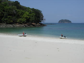
The first evening, we had rum drinks and a potluck dinner on Terra Firma. Jan gave Carrie a piece of dorado from our freezer, and Carrie made some of her excellent ceviche (and no one got sick). The next day we played bocce ball on a powdery white sand beach. The Perlas Islands are very pretty, and there is supposed to be some good snorkeling and diving in the area, but we unfortunately arrived during a red tide, so water clarity was nil, and the sea temp had dropped to the mid 70's. Brrr! But that was OK, as we thoroughly enjoyed our day of playing with our friends on this beautiful beach. |
|
Isla Contadora (2/6-8, 21.3 nm, 5 1/2 hours). Isla Contadora is a good island from which to make the passage to Panama City, so we headed there after a couple of days at Espiritu Santo. Winds were light, so we ended up motoring most of the way, but we caught another nice dorado - excellent! Isla Contadora is the most developed of the Perlas Islands, and it has a number of beautiful houses, a few restaurants and shops, and a couple of GROCERY STORES! We hadn't been in a grocery store since we left Golfito over a month ago. We'd run out of snacks a while back, and Rich was ecstatic to find Cheetos for sale on this island. (Our friends laughed when we told them that after rounding Punta Mala, we checked the contents of our abandon-ship bag and pulled out the crackers which were packed in there for an emergency.) We'd recently turned off our freezer because there was nothing left in it but a couple of ice trays. Groceries on Contadora weren't plentiful or cheap so we didn't buy a lot, but we'd been eating a lot of canned fruits and veggies, and it was nice to have some fresh stuff - especially limes, tomatoes and onions to make ceviche out of that dorado. We used canned tomatoes and dried onions in our last batch of ceviche, and it just wasn't the same. We also ate lunch at a restaurant, which was a nice treat for both the cook (Jan) and the dishwasher (Rich).
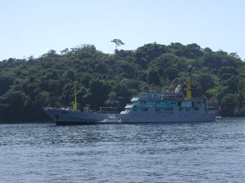
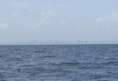
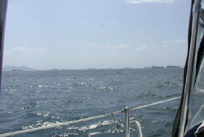
Passage to Balboa, Panama (2/8, 44.8 nm, 9 hours). We weighed anchor early at Isla Contadora, and once again winds were too light (at least when we started out), and we had to motor to Balboa. The winds picked up when we got closer to our destination, but of course, they were on our nose! As we approached Balboa, we saw an impressive skyline of high-rises in Panama City. We hadn't seen a skyline like that since leaving San Diego! We passed through an anchorage of freighters awaiting passage through the Panama Canal, and found our way to the anchorage called "La Playita", which was crowded with about 30 or 40 cruising boats. Anchoring here was a bit of a challenge because the winds had piped up to about 20 knots, and we weren't used to having so many boats around. It took us a few tries to find a good spot and get our anchor set, but we finally settled in. We spent a week at the La Playita Anchorage and then moved to the Balboa Yacht Club for a couple of weeks.
|
|
|
Panama City (2/8-3/4). After spending so much time in remote anchorages and small towns or villages, it was a bit of a culture shock to arrive in a major city. Instead of squawking parrots and howler monkeys, we were hearing traffic noise and discos on shore playing loud music till the wee hours. It was both exciting and overwhelming.
Panama is called the crossroads of the world, and the cruising community here is a reflection of that. As we traveled down the west coasts of Mexico and Central America, the cruisers we met were mostly American or Canadian. Here in Panama, they were from all around the world. One morning, Jan volunteered to be Net Controller for the local radio net, and a British guy suggested having a "boat jumble." Jan had to admit she didn't have a clue what he was talking about. He was suggesting a "swap meet." She later learned that the majority of the cruisers didn't know what a "boat jumble" was, so she didn't feel so embarrassed.
We wanted to transit the Canal in early March, and we had a number of items on "to-do" list before we would be ready. The biggest job on our "to-do" list was installing a new watermaker. Our Spectra watermaker had been the source of many headaches for us over the past couple of years, so we finally gave up trying to make this one dependable and bought a different model. The new watermaker was shipped to us in Panama City, and our head engineer (aka Rich) had a big job ahead of him getting it installed. Our friend Chris was flying in from Virginia at the end of February to help as a line handler for our canal transit, and we were hoping to get our work done so we could sightsee with him when he arrived. (Of course, that didn't happen!)
| Our days were filled over the next couple of weeks - a day
at the airport ransoming our watermaker from Customs; a couple of days doing the
paperwork to arrange our Canal transit; a couple of visits to Allbrook Mall
for new eyeglasses for Rich and other shopping; a couple of trips running around
to various hardware stores in search of plumbing fittings for the
watermaker, as well as the time needed for the installation; two trips for
Rich and one for Jan through the Canal as line handlers to get some
experience prior to Slip Away's transit; and numerous trips for Jan to
various grocery stores. We did a lot of grocery shopping and were delighted to
find almost anything we wanted at reasonable prices. We were expecting to find
higher prices and less selection in the Caribbean, so we wanted to stock up here. One of the best buys we found
was wine. While
in Mexico, Jan found a Chilean Cabernet she really liked (Santa Helena). In Mexico, the wine cost about $7/bottle. She thought it was a great deal
when she found it for $5/bottle in El Salvador. But, she was thrilled when
she found it in Panama for $2.35/bottle. We bought a couple of cases.
Jan somehow managed to find places to stow the hundreds of dollars worth of
food and beverages we bought.
We got to know a few taxi drivers, and they were an incredible help to us - Israel who helped us with the paperwork to check into the country and again with getting our watermaker out of Customs; Taxi Tony who provided great laundry service - pick up and delivery, wash and dry (in a dryer) at a reasonable price; Luis who ran Rich around town looking for plumbing fittings for the watermaker and took us to the airport to pick up Chris when he arrived from Virginia; and Roosevelt, who ran Jan around town on a bunch of miscellaneous errands. Trying to make conversation with Roosevelt, Jan asked him if he was married. He said "no", but told her he had a new son with his girlfriend. Jan commented "Oh, that's nice, how many kids do you have?" When he answered 17, she stopped asking questions. |
|
While days were filled with boat chores and errands, evenings were busy getting together with friends. We caught up here with some folks we hadn't seen for a while, and that was a lot of fun. We were eager to spend time with our cruising friends since we were headed in a different direction than most.
We didn't eat out a lot, but we enjoyed some good and inexpensive meals in Panama City's restaurants. There was a TGI Friday's close to the Balboa Yacht Club, but their U.S. prices were much less appealing than some of the other local places. Every Monday was pizza night - a restaurant near the La Playita anchorage had a two-for-one pizza special. Two individual pizzas and a bucket of five beers cost us less than $10. Another day, our friends Jack & Hermy on Iwa took us to a Chinese restaurant for dim sum, which was outstanding and cost about $4 total for the two of us. Our first day in Panama City, Jan went with some of the other cruising ladies (6 or 7 of them) to lunch and then grocery shopping. We stopped for "fish in a bag", which cost $1 and was sold by a street vendor named Mario. There was a bar on the corner where Mario sold "fish in the bag" and he got the bar owner to open up so we could go in and have a beer with our lunch. Porno movies were playing on TV screens in the bar - that was interesting!!
|
The time flew by, and before we knew it, our transit was just days away. When
our friend Chris arrived,
instead of sightseeing with him, we put him to work - polishing stainless,
hanging the tires/fenders along the sides of Slip Away, grocery shopping with
Jan, stowing the dinghy for the Canal transit (he gave us the
idea to hang it along the mizzen boom), and helping to wash and fuel Slip Away
prior to the transit. We did make time one evening to go out to dinner
with Chris in Casco Antiguo, a Colonial area in Panama City, and we all enjoyed
that. Chris came
back to Panama City a couple of days before his return flight to Virginia, and he
took the time to do some other sightseeing then.
A couple of evenings before our transit, several of our friends gathered at the Balboa Yacht Club bar, and we had a little going away party. When the DJ started playing oldies music, Jan wanted to dance, and she and Celeste from Sol Surfin' had a blast out on the dance floor. Prior to the party, Celeste and Gary had been out running some errands, and Celeste had a tape measure in her bag. For reasons unknown to us, Celeste started going around measuring everyone's heads. We all thought that was hilarious - it's amazing the things that entertain us after a few beers! It was a fun evening, and we were flattered that our friends sent us off with such a fun party. |
|
On March 4 and 5, we transited the Panama Canal. We miss our Pacific cruising community, but we're finding our way around in this new ocean and making a few new friends along the way.