Logbook: Nicaragua & Costa Rica Inland Travel, August 2006
A couple of weeks after returning from Guatemala, we were ready to hit the road again. Actually, we weren't quite "ready" but our tourist visa was running out, and we needed to exit the Union of Central American Countries (El Salvador, Guatemala, Nicaragua and Honduras) for a few days. Since Nicaragua was next on our list of places to visit, the easiest way to solve our visa problem was to travel a few hours further to Costa Rica for our required "time-out" of 72 hours. After that, we could re-enter the Union and get a new 90-day visa.
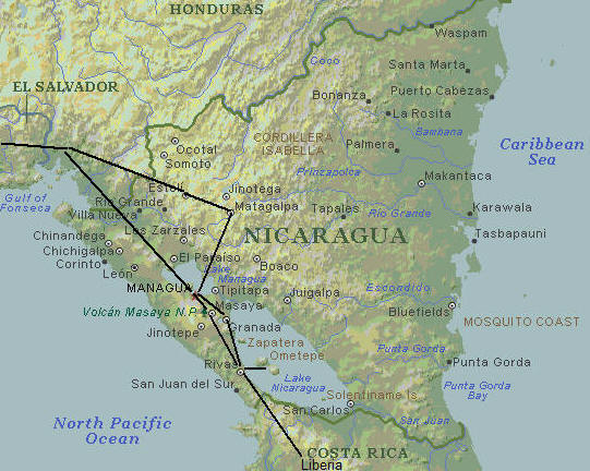
We first took a bus to Managua (11 hours from San Salvador), but since the capital city didn't really offer much of interest to see, we shared a cab with another bus rider and continued on to Granada (45 minutes further). After a few days in Granada, we traveled to Liberia, Costa Rica. We then returned to Nicaragua and visited Isla Ometepe, Masaya, Matagalpa and Esteli.
Ten days into our trip, we arrived in the town of Masaya on a Monday afternoon. We checked our email and received some sad news - Rich's mother, Mary, had passed away the previous Saturday. At that time, we were on Isla Ometepe. Email was the only way Rich's family could reach us, and there was no internet access on the island. It was ironic that we originally planned to stay three nights on Ometepe, but then decided to leave after only two. Something was calling us back to the mainland. Fortunately, Masaya is very close to Managua, and we were able to get a flight to Maryland the next day. We spent a week with Rich's sister's family and participated in the memorial service held at Mary's retirement community in Chestertown, Maryland. We will always remember Mary's lively and generous spirit, and we now have another guardian angel watching over us as we travel. |
|
| Nicaragua covers an area of 50,000 square miles (129,500 sq. km), which makes it slightly larger than the State of New York. It is the largest but also the poorest country in Central America, and the second poorest in the Western Hemisphere (after Haiti). It has a population of approximately 4.5 million and the lowest population density in Central America. The population is primarily Mestizo (a mix of Spanish and indigenous ancestry), with smaller percentages of Europeans, blacks, and indigenous people. 95% of Nicaraguans are Catholic. Baseball is Nicaragua's national sport - they have six major league teams, and lots of locals play the sport. The official currency is the córdoba, but prices were often quoted in American dollars, which are accepted almost everywhere. The ATM even gave us the option of withdrawing dollars or córdobas. |
|
Like most of its Central American neighbors, Nicaragua's past is filled with civil strife. Ever since its colonial days (the 1600's), the Liberal and Conservative Parties in this country have been at odds. Nicaragua gained independence from Spain in 1821, and since then, the country has been run by some notorious presidents and dictators - they and their nefarious activities fill pages of books. In recent history, in 1978, the Sandinistas overthrew the tyrannical Somoza dictatorship, but then instituted their own brand of political oppression. Sandinista President Daniel Ortega held office from 1984 to 1990, and war with the Contras escalated during that time. In a 1990 special election, Ortega lost the presidency to Chamorro (a member of the UNO party opposing the Sandinista Government), and shortly thereafter the Contras stopped fighting. Since then, the country has struggled to make progress, and scandal and corruption has continued in its government. Daniel Ortega has tried to regain the presidency and ran for re-election in 1996 and 2001, but both times he was defeated. Nicaragua will be electing a new president again this fall, and we understand Daniel Ortega is running again and enjoying new popularity. We are waiting anxiously to hear the outcome of these elections.
Nicaragua has also suffered its fair share of natural disasters, including a devastating earthquake in 1972, which killed over 6,000 people and left 300,000 homeless. (Most of the international aid money ended up in the pockets of the dictator Somoza and his cronies.) More recently, Hurricane Mitch in 1998 dealt a severe blow with its heavy rains and ensuing floods and mudslides. Nicaragua is also dealing with environmental problems including rapid deforestation
Although the people here are very poor and the country has had an unsettled history, Nicaragua does not have a reputation for violence or crime, and we felt safer traveling here than in Guatemala. (In Guatemala, we would not venture into remote areas without the accompaniment of a guide or tourist police. In Nicaragua, we went most places on our own, and it was not a concern.)
| A growing number of tourists are
visiting Nicaragua, but the government's investment in tourism has been
sluggish, and travel here can be challenging. Traveling in Nicaragua was
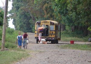
like taking a big step back in time. Few Nicaraguans ("Nicas") own cars; some
get around by bus, but for many the main form of transportation is on a bicycle
or even horseback. It was not unusual to see horse-drawn carts, as well as
a few oxcarts, on their streets. With the exception of the Pan American
Highway, most of the roads in Nicaragua were rough and needing repair.
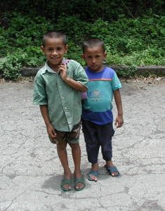
In general, we found most of the Nicas to be warm and friendly albeit more timid than some of the other Central Americans. The kids were incredibly cute and unspoiled by tourism. Many of them are learning English in school, and teachers have told them to say "Hello" when they see gringos - and they do. They would also say "photo" to us because they wanted us to take their picture, but unlike in other countries, they never asked for money for taking their photo. They just wanted to see their photo on the back of our digital camera, which usually made them giggle with delight. With the poverty, we also sadly saw some street kids who were dirty and begging for money. We never gave them money, but after being approached a few times, we gave a couple of them some food, which seemed to satisfy them. We've read that malnourishment is a problem for this country's children and met a mission group in Matagalpa who were helping out at "feeding stations" which were set up to provide nourishing meals to the kids. |
|
The country has three distinct geographical regions:
- the Pacific Lowlands, a hot, fertile plain containing three major cities (Managua, Leon and Granada), most of the population, several large lakes and eleven major volcanoes.
- the North-Central Mountains, a cooler also very fertile agricultural area, not as heavily populated as the lowlands, but hosting a few towns, including Esteli and Matagalpa. (Land mines and ex-Contras make it unsafe to travel beyond the cities into the more remote areas of this region.)
- the Mosquito Coast, the country's Caribbean region and the widest lowland plain in Central America. This occupies about half of Nicaragua's area but is sparsely populated and covered by tropical rainforest.
Granada, Aug. 5-9
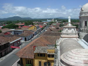
Founded in 1524, Granada is Nicaragua's oldest Spanish city and finest colonial town. It lies at the foot of Mombacho Volcano and on the northwestern shore of Lake Nicaragua. Granada can be accessed from the Caribbean Sea by the San Juan River and Lake Nicaragua, so it was an important trading center in colonial days. Granada was the center for the Conservative Party, and in 1856, the city was torched by William Walker, an American engaged by the Liberals of Leon to help them seize power. Fortunately, Granada was rebuilt.
Granada is part of the Pacific Lowlands, so the climate is hot. The city's present population is about 85,000, and it was the wealthiest city we visited in Nicaragua. We found many of the colonial buildings to be well cared for with fresh coats of paint on the exteriors. This city appeared to be working hard to attract tourism, with success.
| We arrived Granada on a Saturday
evening, and it was also a holiday in Managua (Fiesta of Santo Domingo), so we
had to search a bit to find a hotel room. We finally found a room at La
Siesta, a small guesthouse run by a lovely young couple, Boris and Marcela.
Boris is French, and Marcela is Nicaraguan. They were absolutely
delightful hosts and went out of their way to ensure we got the most out of our
visit to Granada.
We spent our first day in Granada exploring the city on foot. We first visited La Merced Church, where we climbed the belltower for views of the city, Mombacho Volcano and Lake Nicaragua. Since it was Sunday, mass was being held in the church, and we sat down in a back pew for a few minutes just to observe. We noticed a group of four boys in the pew ahead of us - what looked like an older boy of probably 12 or 13, charged with taking his younger brothers to church. They were all eating ice cream cones. We both chuckled at that. We think we would have gotten in trouble if we ate ice cream in church when we were kids. But these kids were well behaved and happy, and we believe God was happy to have them there, ice cream and all. |
|
That day, we also visited Granada's Central Park, their cathedral and the Convent and Church of San Francisco, which was burnt to the ground by Walker in 1856, but completely restored and now houses the city's best museum. We also walked down to the lake front, which we did not find all that impressive, but we enjoyed the walk through the neighborhood, and on our way back, we passed the local baseball diamond where a game was in progress.
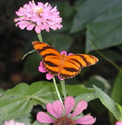
| The next morning, we decided to
take a walk to a Mariposaria (butterfly farm). Boris drew us a map, and we
headed out on foot because that was the only way to get there. It was a long
walk - an hour in the hot sun - and the insight into local life was an
eye-opener. We walked along a rutted dirt road, and on both sides of the road
were houses built from tree branches and sheets of corrugated tin. The
people were friendly, though, and smiled, waved and said "hello" as we walked by.
The butterfly farm was small but very interesting, and the butterflies were numerous and beautiful. The founder of the farm is an American from Pennsylvania who was out of the country at the time of our visit, but his assistant Julio showed us around and told us about their work. Afterward, Julio gave us a ride back to town in the farm's Jeep, which was well worn, but still functional. |
 |
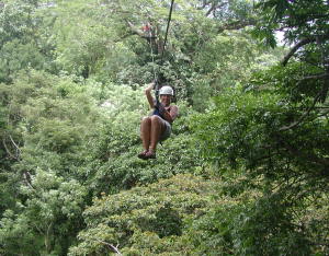
Our final day in Granada, we visited Volcán Mombacho and took their zip-line canopy tour. We had some friends who did similar tours in Mexico, and although it sounded like a lot of fun, the cost of $70/person was a bit steep for our budget. Our guidebook indicated that the cost here was less than $30/person, and the tour was highly recommended.
| When we arrived at Mombacho, our
guides Domingo and Martin immediately took charge of us. They fastened
several straps on our bodies, put helmets on our heads and gave us heavy gloves
for our hands. Then Domingo asked for our camera and instructions on how
to use it because he would be taking the pictures. The canopy ride was 1.5
km long, with 15 platforms, connected by 13 cables and a walk bridge.
Although billed as a "Jungle Canopy Tour," to us, this was more of an amusement
park ride. But it was a blast! It was a rush flying through
the canopy. Domingo and Martin had us trying different poses - Superman
and upside-down - yet they were very safety conscious. Both we and
they were always clipped on to a cable or other structure on the platform.
This was a really fun day!
Volcán Mombacho also had a number of hiking trails, which we would have liked to have checked out, but we didn't have enough time after the Canopy Tour. Also, time was running out on our tourist visa, so we needed to leave for Costa Rica the next day. |
|
Liberia, Costa Rica, Aug. 9-12
From Granada, we were able to catch a TransNica bus directly to Liberia, Costa Rica, which is just a couple of hours south of the Nicaraguan border.
Costa Rica is different from its Central American neighbors in many ways. It has had a primarily democratic government since the late 1800's, and after a short civil war in 1948, it abolished its armed forces. Costa Ricans ("Ticos") enjoy the highest standard of living in Central America, primary education is free and compulsory, and a nationwide system provides free healthcare. With these impressive social services, however, the country has huge public debt. Tourism is one of Costa Rica's top sources of foreign income, and ecotourism is a primary focus. More than 27% of the country is protected lands, and over 14% is within the national park system. Although environmentally focused, deforestation has been a problem in this country. However, they are instituting reforestation programs. Travel here is easier, but more expensive. Ironically, Costa Rica also has a reputation for theft, so we kept an eye on our belongings and our hands on our wallets at all times here.
Since we intend to return to Costa Rica on Slip Away in November, we didn't plan to spend much time here on this trip. Our primary goal was to spend the requisite hours outside the Union of Central American countries so that we could re-enter and get a new tourist visa. Since we needed to stay a couple of days, however, we thought this would be a good opportunity to visit a couple of their national parks.
The town of Liberia isn't a major tourist draw, but it's pleasant and a good base for visiting Rincón de la Vieja and Santa Rosa National Parks. When we arrived in Liberia, we thought we would spend a day in each park, but we liked Rincón de la Vieja so much the first day, we went back the next.
| Created in 1973, Rincón de la
Vieja National Park covers almost 35,000 acres (14,084 hectares). The park
is named after the volcano here, which was highly active in the 1960's, but is
"gently" active at present. Trails in the park pass through
several ecosystems and lead to waterfalls and pools, fumaroles, boiling mud
pools, steam vents and sulfurous springs. Thirty-two rivers and streams
have their sources within this park.
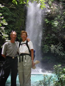
Our first day in Rincón de la Vieja, we hiked 10 km (6.3 miles) roundtrip to the La Cangreja waterfalls. Parts of the hike were rainy and muddy and parts of it were dry and sunny. Twice during our hike we saw groups of the white-faced capuchin monkeys, and the second time, they were really close. We also saw a white-nosed coati (part of the raccoon family - he was begging for food in the parking lot), an agouti (which looks like an oversized cross between a rabbit and a squirrel), some bright green lizards and several beautiful electric-blue morpho butterflies. We heard and saw a number of birds, but we weren't able to identify them. When we arrived at the waterfall, it looked like the pictures we've seen on posters advertising Costa Rica - absolutely beautiful! Our second day, we took an easier trail, a two-mile loop that took us past fumaroles (holes in the earth from which hot smoke and gases escape) and boiling pools of mud and water. Afterward, we headed to some cold water pools, soaked our feet, ate lunch and relaxed. |
|
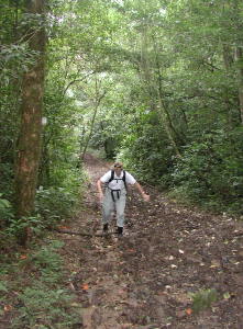
Hiking in Rincón de la Vieja gave us an opportunity to try out our new "hiking" boots. In Guatemala, our good hiking boots took a thrashing from a couple of muddy hikes. Since it was rainy season, we expected hiking would continue to be muddy. We noticed that the local guides wore rubber work boots - what a great idea! We bought some for $5/pair at a hardware store in San Salvador. They were comfortable (no blisters on that first 6 mile hike), and the bottoms had good treads that gripped well in slippery areas. They weren't great on rocks, but that was the only negative. The best part was when the boots got dirty and muddy, we just walked through a stream or stuck our feet in a pool of water. They were great!
After a couple of days in Liberia, we'd done our time and could return to Nicaragua.
Isla Ometepe, August 12-14
| From Liberia, we took a bus to
Rivas, Nicaragua, then a cab to San Jorge, and then a boat to the town of
Moyogalpa on the Island of Ometepe. The boat was old, wooden and rickety -
thank goodness the lake was calm for the 45 minute ride.
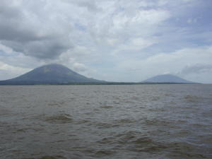
Lake Nicaragua is Central America's largest lake, and Isla Ometepe is the lake's largest island. Ometepe (which means "two hills" in the Nahuatl Indian language) is formed by two large volcanoes - Volcán Concepción, which rises to 5,300 feet (1610 meters) and Volcán Maderas, 4,600 feet (1394 meters). The volcanoes sit next to one another and are connected by an isthmus. 35,000 people live on Ometepe and are scattered among several small towns. Ometepe offers some views of unspoiled natural beauty, but it is sparsely developed for tourism, and it requires a bit of additional effort to travel here. The road around Volcán Concepción is paved, but the road across the isthmus and around Volcán Maderas is not. There were fewer cars and more horses and oxcarts here than on the mainland. It was rural and secluded, and with farmland in the foreground of the towering volcanoes, Jan wondered if perhaps this is what Hawaii looked like about 100 years ago. |
|
While waiting for the boat to Ometepe, a local guy gave us a brochure of tours that were offered on the island - most of which involved hiking on the volcanoes. Both of us were recovering from colds and feeling a bit run down, and the six- to ten-hour hiking tours sounded like too much for us. Our hotel (Charco Verde Inn) was located inside an ecological reserve, and there was a hiking trail of reasonable length (about an hour hike) through the reserve. We hiked the trail the afternoon we arrived and saw howler monkeys and lots of birds. It was beautiful! Our hotel also offered kayaks, but the brown lake water didn't appeal to us. (Yes, we know we're spoiled and snobbish from spending so much time on clear blue ocean waters!) We did enjoy sitting on the beach, and each afternoon, a local rancher brought his herd of cows and horses down to the lake for a drink and a swim.
| The next day, we decided to tour the
island via the local buses. Our hotel was located on the road
that circled Volcán Concepción (the paved road), and we caught a bus to Altagracia,
a small town (population 2000), further along this road. After
walking through Altagracia, we stopped at a hotel for a Coke (no Diet Coke
here), and found a bus schedule posted on the wall. There are only a
couple of buses on the island, and we had an idea about where the buses went,
but no clue about their schedule. Unfortunately, our timing wasn't great -
since it was Sunday, there was reduced service. Although we had hoped to
visit the Volcán Maderas part of the island, we had missed the last bus there.
We still had time, however, to take a bus back to the isthmus road, walk to
Santo Domingo on the isthmus for lunch and get back in time to catch the last
bus back to our hotel.
On our walk along the isthmus road, we saw locals riding their bikes and horses, and ladies washing clothes and swimming in the streams. We walked by a grove of banana trees and houses that provided only basic shelter. Kids we met along the way were very friendly and once again loved having their picture taken. After lunch at a small basic restaurant, we walked back the way we came. On our way back, we passed a baseball game in progress with a number of people gathered to watch. Our day was a little rushed, but we enjoyed seeing the Nicas going about their Sunday activities. |
|
When we arrived back at our hotel, we took another hike up a hill to a mirador (viewpoint). The views were OK, but the trail was steep, hot, unshaded and had very little wildlife. We wished we had re-hiked the trail we did the previous day.
The next morning, we caught a bus back to Moyogalpa and boarded the rickety wooden old boat for the trip back to San Jorge. Winds had been blowing all night long, so the lake wasn't as calm as the trip to the island. It was a bit unsettling traveling on this boat filled with people with five-foot swells on the lake. This boat had a TV and VCR on it, and the captain had a tape of "Big Time Wrestling" which he played during the crossing. That was interesting ...
Masaya, Aug. 14-15
Masaya (population 110,500) is a working-class town, but it is known for work produced by local artists - cotton hammocks, colorful basketry and woven mats, carved and painted gourds, wood carvings, paintings, ceramics and pottery, jewelry and leatherwork. This looked to us to be a good one-day stopover on our way to the north-central mountains.
Upon arrival, we found a hotel, ate some lunch and then checked our e-mail since we'd been out of touch for a few days. It was then that we learned that Rich's mom had passed away two days earlier, so we sat down and talked about what to do and then made arrangements to get back to the U.S.
As a city, Matagalpa did not appeal to us, but we never saw the mercado where the artists crafts are sold. We did walk down to the Malecon, a lakeside promenade along Laguna de Masaya. The lake looked pretty, but the promenade was pretty deteriorated. We read that a series of earthquakes in 2000 left much of this city in ruins. Reconstruction has unfortunately been slow.
The next morning, the hotel owner helped us negotiate a good cab fare to get us to Managua (30 minutes away), where we caught our flight back to the U.S.
Matagalpa & Selva Negra, Aug. 22-23
When we arrived back in Managua after our trip to the States, we caught a bus and headed for Matagalpa, a town in the north-central mountain area. Matagalpa is a town of 76,000, and the mountain climate is very pleasant. From Matagalpa, we wanted to visit Selva Negra, a private reserve and coffee plantation just outside the city.
| When we checked into our hotel,
we got their last available room. The hotel was booked by a group of Canadian women who were
there as missionaries, working at feeding stations in the area to help provide
nourishing meals for kids. Rich was outnumbered here, but we enjoyed
visiting with these ladies who we guessed ranged in age from teens to 60's.
Their trip leader was a career missionary, and she told us about the work they
were doing in Nicaragua, as well as some of her previous experiences in
Columbia. Most of the other ladies were volunteers for this ten-day trip.
They were a nice group, and they were quite intrigued when we told them of our
life on a sailboat.
The next day, we caught a local bus to Selva Negra, which was about 30 minutes from Matagalpa. Selva Negra was founded in the 1880's by German immigrants who came at the invitation of the Nicaraguan government to grow coffee. Literally translated, Selva Negra means "Black Forest." Descendents of the founders still manage the estate. Selva Negra covers 2,100 acres (850 hectares), and over half is protected rain forest. The forest is home to howler monkeys, numerous bird species and other animals, and there is a network of hiking trails on the grounds. We spent several hours hiking in this beautiful reserve and then ate lunch at their restaurant, which has a porch overlooking a small lake. We didn't see the monkeys but we heard them howling as we ate lunch. We also enjoyed the museum inside the restaurant which included lots of old photos and some old pieces of equipment. |
|
The next day, as we waited for our bus to Esteli, Jan made another new friend. A little boy sat down next to her on the bench and wanted to speak English with her. He was eleven years old, well mannered and cute as a button, and they had a nice little conversation as we waited for our bus.
Esteli, Aug. 24-25
Esteli has a population of 88,000, and it is the principal town between Managua and the Honduran border. Esteli saw heavy fighting during the revolution and afterward the town remained one of the Sandinistas' strongest support bases. Seventeen miles (28 km) northeast of Esteli is Miraflor Nature Reserve. When we lived in Ensenada, Mexico, we became friends with a man named Alberto, who was originally from Nicaragua. Alberto highly recommended visiting Laguna de Miraflor where he once had a summer home, and our guidebook said it offers some of the best hiking in the country.
Our hotel in Esteli told us which bus we could take to Miraflor, but they had no further information, and although our guidebook mentioned Miraflor, there were few details. We finally found a Miraflor office in Esteli, and they gave us a map, confirmed the bus schedule (6 a.m. departure), and told us at which stop to get off. They told us the bus would take 1½ to 2 hours to get there - since it was only 17 miles away, we figured the roads must be pretty bad. The Miraflor office also told us that we could pay for meals and a guide through their office. We paid for breakfast and services of a guide, and although they gave us a receipt, we walked out of the office wondering if we just made a donation to the Miraflor Nature Reserve.
When we caught the bus the next morning, it was still dark, so we didn't notice the heavy clouds overhead. The route to Miraflor was uphill from Esteli, and as the bus climbed the bumpy, unpaved road and the day dawned, it started to rain. When we got off at our stop, there was a nice shelter, and we stopped to don our rain ponchos. Another local lady got off the bus with us, and we noticed she had several things to carry - too much for one person. We asked if she needed some help, and she said someone was supposed to meet her, but she seemed concerned that they weren't there yet. We showed her the map given to us by the Miraflor office, and she showed us where her house was, and it was on our way. We would have felt bad leaving her at the bus stop with all that stuff, so we offered to help her carry her packages. One of them was a large basket, and as we lifted it to help her put it on top of her head, we realized it was full of live chickens! With the chickens flopping around, it was a real challenge for her to keep that basket balanced on her head! We each took a shoulder bag and carried a heavy cooler between us. We walked with her about a half mile (in the rain, through some big puddles), and then her daughter showed up on a horse to help her take the things the rest of the way home. The woman offered to make us coffee or breakfast, but we graciously declined since we were expecting to have breakfast a bit further down the road.
We continued walking toward the area shown on our map and saw a few signs which gave us come confidence that we were heading in the right direction. The woman at the office in Esteli told us the walk was about a mile, which should have taken about 20 minutes, but we walked for about 45. We finally came upon a couple of local houses and saw a sign for a Visitor Center, but the gate was locked. There was a hole in the fence that looked well used, so we climbed through it and continued a short distance until we came upon a large building, which we assumed was the Visitor Center. But it was surrounded by a barbed wire fence and the gate was locked. We stood for a while in the rain, hollering "Hola" at the house, and finally, two people came outside. They got on a motorcycle and came toward the gate. We talked to them and told them we were here to visit the park, and that we had paid for breakfast and a guide. The guy on the motorcycle was a guide, but he was headed to Esteli for the day. The other guide whose name was given to us at the office wasn't there either. Fortunately, this young man said he would help us find our way, and we followed him back to the couple of local houses near where we climbed through the fence. The one house had a mother and five or six kids in it, and they sent one of the kids off to find "Juliana." Rich kept looking at this house and saying "No way am I eating here!" Jan told him to remain calm, and in short order, the kid returned with Juliana, who was a young girl of maybe 13 or 14. We showed Juliana our receipts, and she seemed to be somewhat informed. She said she could be our guide, and she would talk to someone about getting breakfast for us. She came back a few minutes later and told us that the woman in the other local house would make us breakfast. She asked if we wanted to walk around a bit while they made breakfast, but since it was foggy and rainy and we were hungry, we told her we would just wait.
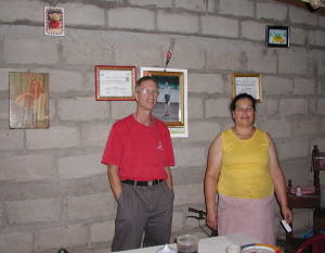
| Juliana walked us over to the home of the Blandon family, which was a couple of rooms with cinderblock walls, a tin roof and a dirt floor. Although very basic, there were some family photos and a diploma hanging on the one wall, and we were surprised that they also had a black and white TV! The woman of the house, Sra. Blandon, cooked up some eggs, beans, tortillas, cheese and coffee, and we cleaned our plates. Juliana told us we should give Sra. Blandon our breakfast receipt, and it was our understanding that with this receipt, she would get paid by the Miraflor office. When we asked Sra. Blandon if she got many tourists for breakfast, she told us we were the first. After breakfast, Jan asked if she could use the bathroom, and Sra. Blandon pointed outside, where Jan found two outhouses. The first had a rock over the hole and three chickens in it, so she checked out the other one, which had a "privacy" curtain. With the winds blowing that morning, it offered little privacy, but then, in this remote area, little privacy was needed! |
|
While eating breakfast, we discussed our options for the day. It was continuing to rain outside, and it was foggy (perhaps that was the cloud forest). Bus service along this route was infrequent. We thought we could catch a bus back at 11:30, but if we didn't catch that one, the next one was at 4 p.m. We had an additional concern that we had paid a travel agency $60 for bus tickets back to San Salvador the following day. We had a receipt, but no tickets as yet. The travel agency was closing at 6 p.m., and they knew we went to Miraflor for the day. They told us if we weren't back 6, they would deliver our tickets to our hotel. However, given our experiences so far, we were not confident that would happen.
We made the decision to call it a day. Juliana seemed disappointed but agreed it wasn't a good day to go hiking in the reserve. She told us that maybe we could go by the Miraflor office to get a refund for the guide service, but since she had been so helpful, we gave her our receipt so she could get the money for it. Our guess is she doesn't get many opportunities to guide tourists, and she was really a sweetheart.
We walked back to the bus stop, and it continued to rain. As we waited for the bus, several local teenagers showed up and waited for the bus with us. Many of them didn't have umbrellas and were soaking wet, but it didn't seem to bother any of them, as they laughed and joked and goofed around while waiting for the bus. They were quite entertaining. In short order, the bus showed up and took us all to Esteli.
While we didn't quite accomplish what we set out to do this day, we still had a good day. The area was very pretty and we enjoyed the walks in the rain, but mostly we enjoyed all of our interaction with the local people. Our biggest regret was that with all the rain, we didn't take any pictures. The memories of this day will have to stay in our minds.
When we got back to Esteli, after a couple hours of follow-up, we finally got our bus tickets back to San Salvador for the next morning. When the travel agent gave us our tickets, he thanked us for coming to Esteli. He told us they had tourism in this area in the past, but since the Sandinista revolution, tourists have been rare.
Esteli to San Salvador, Aug. 26
The travel agent told us our bus was coming from Managua and would pick us up at Star Mart, a large Texaco gas station on the edge of town, at 7 a.m. "official" time ("hora oficial") the next morning. We showed him our watch, and he assured us we were on "official" time. We showed up at Star Mart at 6:30, and by 7:30, we were getting a bit concerned. Jan asked the security guard if he knew what time the King Quality bus would show up, and the guard told her it would come at 8 a.m. Thank goodness "hora oficial" was an hour later and not an hour earlier!
The bus showed up at 8, and we boarded and settled in for the 8½ hour ride to San Salvador. King Quality is a luxury bus line, and they have comfortable seats, air conditioning (so cold we needed blankets) and movies. The also serve meals, and although the passengers who started the trip in Managua already had their breakfast, the attendant saved two meals for us, and she brought them to us shortly after departing Esteli. (We were the only two passengers who got on the bus in Esteli.)
Our trip to San Salvador took us through Honduras, and although Nicaragua, Honduras and El Salvador are part of the Union of Central American countries, we still had to clear customs and immigration (and pay some money) as we crossed the borders. While in Honduras, our bus had to go through a drug inspection stop, where we got off the bus, men and women were lined up separately, and a very surly man scrutinized each of us and our passports. He was especially rude to a couple of Korean tourists. The El Salvador immigration official was also quite gruff to us when he saw we were on a second tourist visa, asking us what was our purpose here and how much longer were we staying. (He obviously hadn't received his lesson from the Department of Tourism on welcoming tourists into the country!)
After crossing the border into El Salvador, we were served lunch - a box which contained a small bag of quesitos (like cheetos), a twinkie and a piece of candy (one of those sugar-coated jelly things). Rich waited patiently for them to bring a sandwich or something to go with it, but realized this was "it" when the attendant started to collect the empty boxes.
We arrived in San Salvador at 3:30 p.m., which was too late to catch a local bus back to Bahia del Sol, but we had called our friend and taxi driver Jose the day before, and he met us at the bus station. On our way back to Slip Away, Jose stopped at a grocery store so we could buy some provisions. Our friend Boris dinghied us out to Slip Away. It felt especially good to be home.
Final thoughts ...
We enjoyed our travels in Nicaragua, but it did not come without its challenges. Traveling to areas where there are few tourists has its appeal and gave us more of an opportunity to interact with the locals, but it required more effort to figure out where to go and how to get there. Initially, we enjoyed the challenges and got a sense of satisfaction from figuring things out, but it eventually wore on us and sometimes really frustrated us. Although not planned this way, our trip ended up being less about seeing sights and more about insights into life in a third-world country - more of an education than a vacation.
| Nicaragua is still struggling with
providing basic services to its people. Two afternoons while we were in
Granada, the water was off, making it impossible to wash our hands before
eating lunch (not to mention flush the toilet).
Fortunately, the water came back on later in the afternoon. While we were in Matagalpa, the city was without electricity from about 10 a.m. to 8 p.m.
both
days. The sun set around 7 p.m., and one evening, we ate dinner a little too
late. It was pitch black as we walked back to our hotel. Fortunately,
we thought to bring a flashlight with us, because the sidewalks were uneven and
potholed, and it would have been easy to trip and fall. Matagalpa was the
only place where we had the option of a hot shower, but the hot water only
worked if there was electricity. In the hot climate of the lowlands, a
cold shower was just fine, but in the mountains, a warm shower would have been
nice. Hot-water showerheads were a little scary - a cold-water showerhead
with an electric heating element, which some friends of ours have aptly named a
"suicide shower." (We also found these throughout Guatemala.)
Nicaragua has a lot of work ahead of them if they want to start attracting more tourists. Granada was really an exception in this country. Granada has good hotels, restaurants and sights, and one can find their way around pretty easily. Outside of Granada, it was more of a challenge. Most of the towns offered few restaurants and little variety (lots of chicken, rice and beans). But then, most of the locals cannot afford to eat at restaurants, and there's not enough tourism to support them. The country faces the quandary of investing money in tourism when tourism hasn't yet arrived. There's also the question of whether tourism would be the right place to invest when their money could be spent on education, nutrition or healthcare. |
|
In spite of the extra effort expended traveling in Nicaragua, we enjoyed it. Our excursion to Miraflor, although a day full of challenges, was very rich in terms of our experiences and the local people we met. The Nicas were always friendly and helpful to us. We often found ourselves asking people on the street for directions, and on buses, we usually asked a seatmate and/or the money collector to tell us when we arrived at our stop, and they were happy to oblige. As we've mentioned before, the kids in this country were a delight. Most were friendly and happy, and enjoyed an innocence we rarely see. It's amazing how these folks get by so well with so little. Going back to the States in the middle of our Nicaragua travels was a bit of a culture shock. I just kept thinking - we have so much!
We've given ourselves a little pat on the back for taking the time to learn some Spanish, because traveling in Nicaragua would have been much more difficult without basic language skills. We met very few people who spoke more than just a few words of English. We are far from fluent in Spanish and often had a hard time understanding some people, especially those from outside the cities. (Imagine someone learning English and trying to speak with an American from the hills of Tennessee.) But, we could get by, and the locals appreciated our efforts - no matter how badly we butchered some words or sentences.
Although we intended to also visit Honduras during these travels, after our unexpected trip to the States, we decided to cut our journey short and return to Slip Away. We enjoyed our last few days in Nicaragua, but after the challenges of that travel, coupled with the emotional toll of losing Rich's mom, we were quite happy to get home to the familiar surroundings and comforts of Slip Away.